Image: Abd Almohiman Sayed, via Getty Images
Initiative aims to use satellite data for damage inventories, risk maps and environmental impact reports
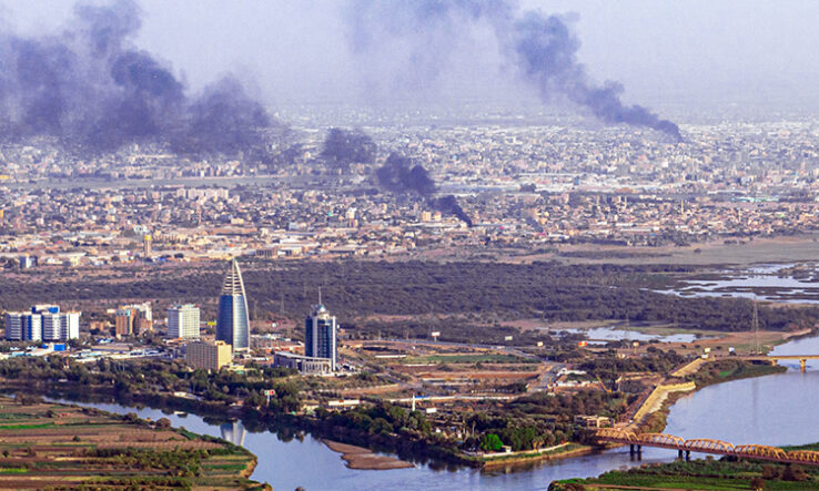
Sudanese scientists are planning to establish an environmental observatory that will use satellite data to monitor war damage and help inform post-conflict resettlement and rebuilding efforts.
Plans for the Sudan War Environmental Consequences Observatory (Sweco) were announced by Nadir Hassanein, general director of the University of Khartoum Consulting Corporation, in a post on the social networking site LinkedIn on 10 April.
According to its website, the University of Khartoum Consulting Corporation is a private company that draws on more than 800 experts to provide consultancy services in fields including engineering, health and environmental science.
Once established, Sweco will allow journalists, scientists, researchers and engineers in Sudan to rapidly assess environmental and infrastructure damage, Hassanein writes in his post. Modern satellite imagery allows for regular, near real-time coverage of wide areas at a relatively low cost, he says.
Measuring damage
The Sudanese Armed Forces and the Rapid Support Forces, two rival factions of the military government, have been at war across Sudan since April 2023.
This has caused damage to water infrastructure, power plants, oil and gas facilities, sewage facilities and agro-processing facilities, causing “multiple air pollution incidents and potentially serious contamination of ground and surface waters”, Hassanein writes.
Sweco will “monitor and record the character, magnitude and significance” of the damage in each sector, using high-resolution satellite data and information collected by volunteers working on the ground.
The observatory will also create damage inventories for other war impacts, including impacts on food security, education, healthcare and the climate agenda, he says.
Guide for rebuilding
Sweco’s data will inform environmental management plans to “restore and protect the environment, address social challenges and promote sustainable development in post-war contexts”, writes Hassanein.
He adds that the observatory will alert the public about health and safety threats and assist with information to resettle displaced populations once the conflict ends.
“Tailored, data-rich maps identifying the intersecting urban and climate risks are vital to understanding where the greatest threats [are] to the cities’ most vulnerable populations, and where to build infrastructure like sewers, clean water systems and drainage to help manage and sustain the new influx of people fleeing conflict,” he writes.
Hassanein’s note does not indicate where the funding for the observatory will come from or how it will obtain the satellite imagery it needs.